
Above is a copy of the Hawaiian Volcano Observatory ‘deformation’: inflation/deflation graph showing inflation trending very high right now.
Satellite Central Pacific Water Vapor Imagery loops are showing very heavy rain broiling just south by southwest of the Hawaiian Islands, so much so they have named it Tropical Storm Neki with winds of 40 mph. Neki is forecasted to miss the Islands to the west.
Pouring rain starting late last night continues as I write. These rains are independent of the storm to the Southwest. Local radar shows oncoming scattered showers.
I listened to large south swell pounding the southeast shores all night but is subsiding today.
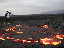
I spoke with geologists returning from documenting the molten lava flowing on the coastal plains below Royal Gardens subdivision (long destroyed by lava) and coastal lava pouring into the sea. They saw four large fingers of lava that “was really hot and moving”; if it continues on course we could soon be watching flowing lava go by out at the official Civil Defense viewing area; something not seen there since June 2008.
Last night visitors to that viewing area witnessed a beautiful sunset, strong ocean entry plume, fingers of molten red lava flowing off the distant new bench of land and into the sea, as well as a few small fireworks of explosions – all with the bright planet Jupiter hanging right overhead. With this new onset of very strong inflation all the lava flowing may become more exciting the next few days.


No comments:
Post a Comment